A PSA for anyone who has never seen a map of the “city” of Los Angeles:
This is not the map of a city. This is a map showing the armistice line of a frozen conflict. In the ’90s and 2000s, many maps of a hypothetical Palestinian state were drawn that included a “land corridor” that joined Gaza with the West Bank. The rump of San Pedro and Wilmington is joined with the main body of the “city” with a land corridor that looks the same as those proposed maps. Having traveled on the LA Metro from Long Beach to DTLA, I fully understand the need for a land corridor that allows travelers to enjoy the protection of the LAPD and Long Beach PD without exposure to the “protection” of LA County Sheriff’s deputies.
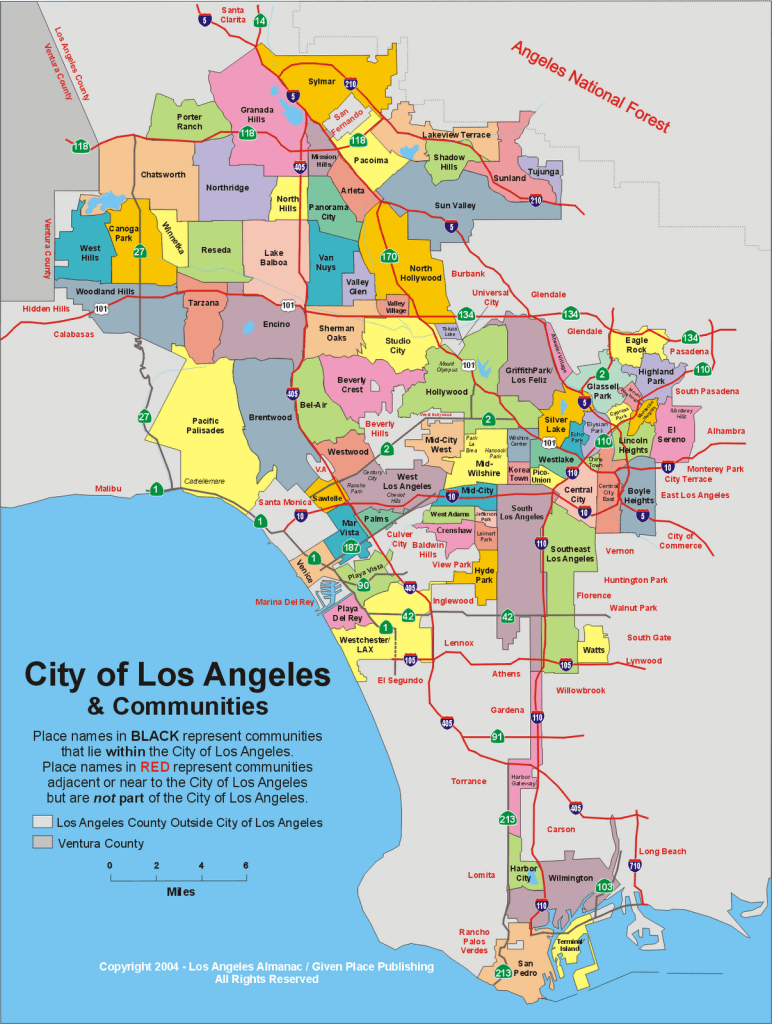
There’s another similarity with the proposed maps for the resolution of Israel-Palestine. The proposed maps of the west bank include carve-outs for the large “settlement blocks”. The main body of the “city ” of LA also includes carve-outs shown in grey: Santa Monica, Beverly Hills, West Hollywood and Culver City. These are grey because they aren’t neighborhoods within the “city” of LA. Instead, they are incorporated as self-standing cities so their affluent residents don’t have to pay for the education of poor people’s children. A good analogy would be The Upper East Side of Manhattan deciding to separate itself from New York City so that its residents didn’t have to contribute to educating children in the South Bronx. The remainder, after these carve-outs, is a massively underfunded school district with four-and-a-half million residents and an army of heavily armed school resource officers with some randomly located cultural institutions, some nice beaches and interesting but highly dispersed ethnic enclaves.

One thought on “The Armistice Line of a Frozen Conflict”